Friday, December 30, 2016

Conclusions II

Study Area Comparisons

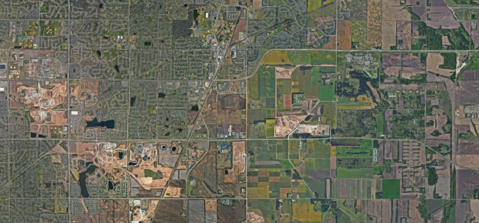
Four study areas were chosen in this report because they appeared to embody characteristics that were typical of many other neighborhoods in the city. In each of these areas a single block was chosen for data collection that was representative of the wider neighborhood. A wide range of measures was taken in an attempt to record the essential attributes of each block objectively and for comparison with the other study blocks. These measures included many of standard tools of urban planning and urban design: population density, building coverage, parking ratios, street widths; as well as a few unusual measures: frontage per entrance, historic population estimate, median parcel size.

Because the study collected a wide range of data points it is possible to see how the differences and similarities of the neighborhoods shows up in the numbers. These are all dense, urban neighborhoods, and as such they do have much in common. However each is composed of a different type of buildings, the physical attributes of which give the neighborhood much of its character. Can those attributes be measured in order to understand the why the qualitative differences one perceives when visiting are so clear?

Many of the measures are not helpful for distinguishing between neighborhoods. Some vary little, some move arbitrarily, some provide us with context without revealing anything about the study block itself. Some of the quantitative measures show little difference between the neighborhoods.

There were a few measures that showed important differences between the neighborhoods related to the form of the neighborhoods themselves. Several of these show a clear direction of change: number of parcels, median parcel size, building count, parking ratio and vehicle traffic mode. These measures all move in one direction with building age from Indre By to Sluseholmen. This seems to reflect the centralization of development decision-making and resources into fewer hands over time as well as the rise of automobile ownership.

A few other measures of the form of the neighborhood showed something a little different. Street-level shop count, building coverage, block size, courtyard size - these measures all move in a certain direction in parrallel with building age, until the Sluseholmen study block, where the direction is reversed. Sluseholmen was designed to recreate some of the feel of a historic neighborhood, so it makes sense that this is reflected in the measurements. Clearly, whether intentionally or not they’ve recreated a few of these aspects.

Are these measurements really getting at the most important differences between these places? Building coverage is a crude measure, and the success street-level shops are dependent on the qualities of a neighborhood at least as much as they help to shape it. The grain size of a place - which shows up in block size and courtyard size, is clearly important, and in this degree Sluseholmen shows real progress. Still, we hardly know anything about a place if we just know that it has small blocks. What are the qualities that these measures are hinting at, and what are they obscuring?

Further Research

Several dynamics revealed themselves during the course of the research which seemed to have strong effects on the quality of different neighborhoods depending on the type of building that predominated. The effect of these dynamics on the built form of different cities and neighborhoods could provide rich areas for further study.:

1. Centralization/decentralization of planning, design, construction and ownership

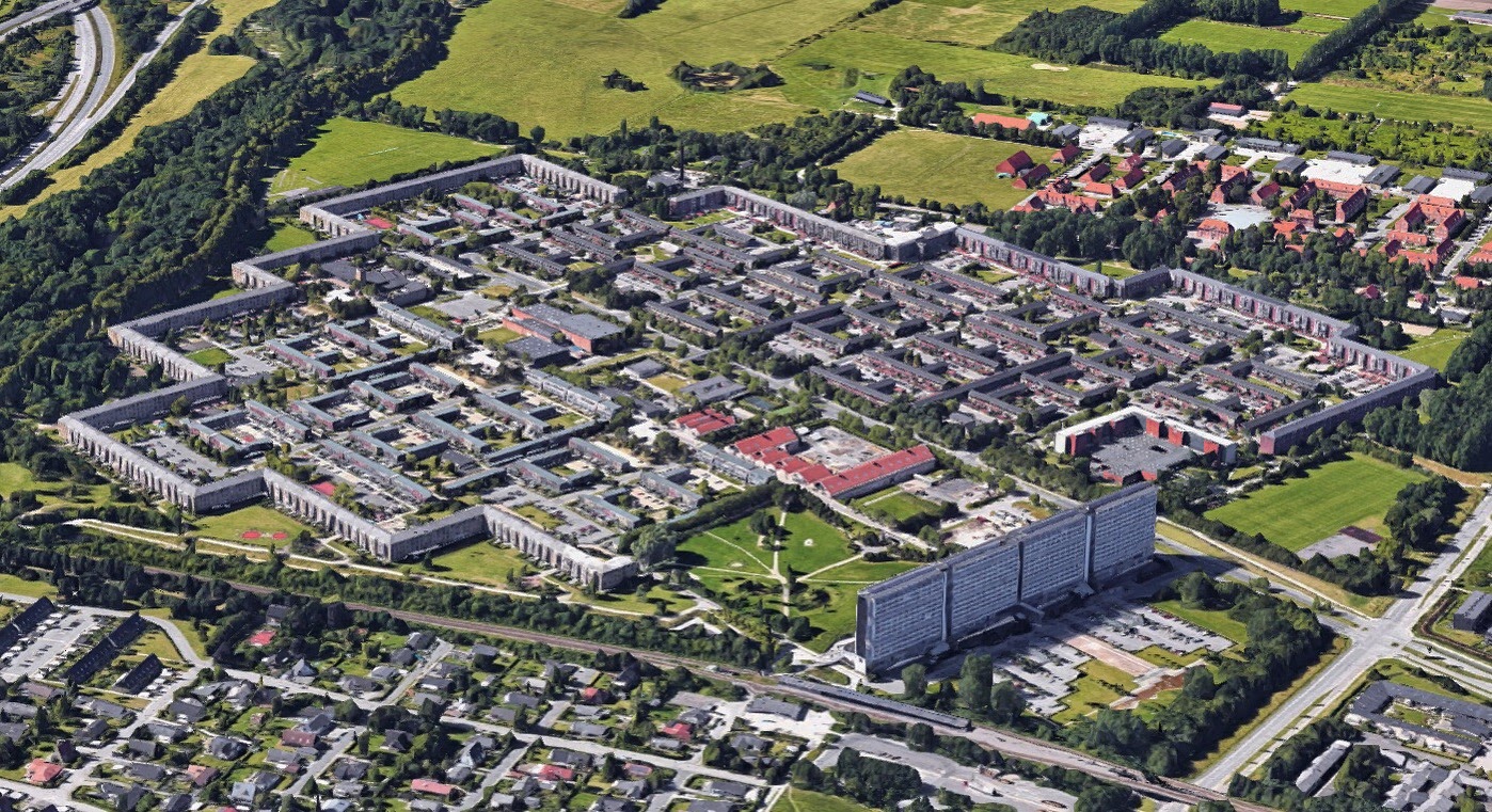
The number of decision-makers at each level of the creation and maintenance of residential buildings changes drastically over the range of neighborhoods studied. In the case of the Welfare Era building there was an exceptional degree of centralization. This tended to have the effect of maximizing those values prioritized by the bureaucracy, apartment size, integration with infrastructure, and efficiency of construction.
In the case of the Golden Era townhouse individual building owners made decisions about the design of their buildings, but their decisions were based on a common framework of vernacular design as well as design-plans made available by the court architects. The street and parcel grid were essentially inherited from medieval times, and construction outfits would have been small groups of craftsmen and laborers. The devolution of decision-making authority to more actors and to traditional practices seems to create a more complex built landscape, while centralized planning can provide structure and coherence. The situation in which many actors are making decisions within an overall strong frame work seems to result in the most successful neighborhoods.

2. Orientation outwards/inwards

 A marked difference between the 19th century neighborhoods and the 20th-21st century neighborhoods lies in the orientation of their buildings. In the Golden Era and Industrial Era building types the building is clearly oriented towards the street to the public: street-facades are more ornate, living-rooms face the street, while courtyards were cluttered with refuse, human waste, and poorer-quality buildings and plain facades.
Welfare Era buildings take a sharp swing in the opposite direction. Ostentation is abandoned in favor fairness and elevation of human dignity in the form of improved living conditions for all. These buildings turn inwards, focused on modern dwelling quarters and spacious courtyards. Livability Era buildings generally maintain this orientation away from the street, although ostentation in the form of architectural avant-gardism has made a comeback. These buildings are designed for residents to take pleasure in their homes, not to go out into society searching for something.
This shift in orientation is preserved in the built landscape of the neighborhoods composed of these different types. It seems no accident that the most lively nightlife zones are located in neighborhoods composed of elements built to engage with society.

3. Specialization of function and class

There is a strong chronological trend towards increasing specialization in the building types described. The Golden Era type is vertically stratified by class, with servants living in attics and wealthy families on the first floor. Shopkeepers and pub-keepers are operating out of the cellars and light industry or animal husbandry is taking place in the courtyard. The Industrial Era type generally maintains these arrangements, though industry is starting to move to specialized districts and the poor are more often constrained to the crowded back buildings in the courtyard.
Welfare Era buildings by contrast are enormously specialized by function and class. They are made of identical dwelling units with identical prices. They are built to provide  the best possible housing and this is nearly the only thing they do. While the Livability type makes concessions to the mixing of uses, they are nearly as specialized as the Welfare Era type especially in terms of socio-economic class, as these buildings rarely contain subsidized units.

4. Purpose of creation

Buildings of each type were created for different purposes, the effects which were expressed in their design and location. Golden Era townhouses were built by wealthy families to establish their stake in the city. The Industrial Era type was built to turn a profit. The Welfare Era type was built to advance society (and sometimes to develop voting constituencies in suburban jurisdictions). The Livability Era type was built both to turn a profit for developers and to strengthen the city financially.
The purposes behind the creation of each other neighborhoods profiled is revealing too. Like the Golden Era bourgeois, the hippies of Christiania sought to establish their stake in the city. Nyboder was built to strengthen the power of the state, while the urban renewal projects in Norrebro were an attempt by the state to change an existing neighborhood for its own good. City planners and citizens should be conscious of the motives behind their planning and building projects as these will likely be permanently expressed in the form of the built environment they create.

Tuesday, December 27, 2016

Back in the grid


My flight home took me over the North Sea, Greenland, and Nunavut Canada. We left Frankfurt around 1pm and got into Seattle at 1pm local time - a nine hour flight over nine time zones. It was the day after the winter solstice, so as we went up into the Arctic Circle even though it was still 1pm there it was dusk - on my side of the plane at least, with an unending dawn on the other. The barren, icy peaks and smooth glaciers of Greenland had an eerie blue glow to them in this midday twilight.


Once we got down into the settled part of Canada I noticed something that signaled I had returned to North America. We were flying over vast forests speckled with lake and through it were roads running in confident straight lines across the land, intersecting one another at right angles.

This grid of country roads extends south into my home state and covers most of the continent north of Mexico. On the USA side of the border it is based on Public Land Survey system, which organized the entire country east of the Appalachians into townships of 36 square miles each. This grid made the administration and transfer of land easy for bureaucrats, boosters and settlers based hundreds or thousands of miles away. 


The organization of land based on abstract models is characteristic of powerful governments expanding into new territory. It prioritizes large-scale organizational efficiency over local decisions based on topography, resources and networks. In Europe it can be seen in some Greek colonies, Roman army camps and cities, and Renaissance expansions to old medieval towns. In the America's you can see it in both the cities of the Aztecs and of the Spanish, and much later in the cities of the Anglo settlers of the United States and Canada. At the grandest scale, the invention of latitude and longitude to mark out precise coordinates on the globe applied a grid to the entire world. 

As far as I know however, the creation of the Public Land Survey in the USA was the earliest use of such an abstract organizational system for land settlement at the continental scale. Settlements still arose at strategic locations based on natural features and connections to other settlements, but these new settlements could share orientation and arrangement with cities and towns hundreds of miles away. Most American towns have the federal government in their DNA.

As the country was populated and cities sprawled, the 36 square-mile sections of each township became the organizing structure of new settlements. "Section-line roads" followed the paths of least bureaucratic resistance from growing towns and cities - the coarse grid formed by these thoroughfares provided the minimum network necessary for postwar suburban developments.


The creation of a built environment based on a continent spanning matrix and filled in by profit-seeking enterprises often gives the populated American landscape a particular feeling of blandness and meaninglessness. It is this emptiness that has motivated a new generation to seek out authenticity wherever they can find it, and to seek to create places that have some kind of meaning. The challenge is great because the large-scale systems which generated our sprawling everytowns have been refined and strengthened over the years. It has been a thrilling and experience to travel to Europe and be in places that are much older, that came together slowly, through the decisions of many individuals based on collective wisdom and the observations of the particular circumstance. It is very good to be home, but it is unnerving to find myself once more in the grid.

Sunday, December 18, 2016

Conclusions I

What are dense neighborhoods like in Copenhagen? What elements comprise these neighborhoods? What are the predominant building types? How do typical buildings shape their form?

This research project was undertaken to answer the above questions. We have learned about the character and history of a range of neighborhoods in Copenhagen. Those neighborhoods that had the most to say about the city as a whole were selected for further analysis, and a fundamental building type of was described for each of these neighborhoods which arises from its history and determines its structure and character.

Despite the differences between these types there is also a clear lineage among them. These related types share features despite the more than 200 year time span and enormous advances in technology they encompass. These include:

Stairwell organization: with two or three units on each floor grouped around a stairwell. This eliminates the need for internal corridors and by provides greater interaction with the street than a single entry point. It also makes possible narrower buildings than are common in Seattle.
Narrow buildings: ranging from about 9 to 12 m ( ft) in width in most cases. This increases the feasibility of linear arrangements.

Linear arrangements: especially the encirclement of the block.
Natural light from two directions: with windows both of the street and courtyard sides. This is possible because of the lack of internal corridors and the narrowness of buildings.

Courtyards: creating an area which is clearly removed from the public realm. These are present for most of the building types described, with the exception of the late-stage Welfare Era type. This maximizes the usable land for residents by devoting nearly all the unbuilt land to a semi-private use. Of course, courtyards must be well maintained and somewhat limited in size in order to maintain their usefulness and privacy.

Limited Height: The building types described fall within the range of 3-6 stories tall. Elevators did not become universal in multi-story buildings in Copenhagen until quite recently and even then they did not lead to a dramatic increase in height, with the taller Livability Era apartments only rising to a maximum of about 12 stories. This means that these buildings have a stronger connection with the ground level and the population is distributed more evenly across the city than would occur with high-rise development.

Masonry and concrete construction: In the early 19th century half-timber construction was abandoned in favor of bricks. Wood beams were used as lateral elements - for floors and roofs, until concrete construction became widespread in the 1950’s. The lack of earthquake risk means that even old masonry buildings are safe for habitation. This reduces redevelopment pressure on historic areas, strengthening the connection to historic built fabric.


All of these features have been regulated by the government in some fashion historically and in the present. Some early regulations are discussed in the report, although as time goes on housing legislation becomes more detailed and less accessible to the English-speaking researcher. Generally we can say that regulation merely codifies some version of what society deems acceptable, and that it is therefore one of many factors that goes into the shaping of building traditions.

The above qualities all contrast with the common characteristics of multi-family housing in Seattle which generally consists of freestanding, thick, double-loaded corridor buildings of highly variable height. Mid-rise multi-family buildings are now constructed of wood and older masonry structures are in need of seismic retrofits due to earthquake risk. These buildings occupy small areas of the city creating pockets of high population density surrounded by large areas of single-family homes.

My interest in the distinct morphologies created by our respective building types and traditions is what prompted this study. The effects that these morphologies have on the quality of public realms is worth researching further.

Sydhavn


Southwest of Vesterbro railroad tracks and industrial land occupy large areas of land creating barriers to movement. Two large parks occupy a significant portion of what is left. In the spaces between these elements the neighborhood of Sydhavn ("South Harbor") is located.

Sydhavn is a working-class neighborhood, composed exclusively of large blocks of flats constructed in the early 20th century. These brick buildings are 5 and 6 stories high and present continuous, unadorned facades to the street. Landscaped areas are spread throughout the neighborhood in open areas between buildings and the street and in building courtyards, some of which are open on one side. These courtyards are large open spaces purposely designed to be amenities for residents, and have never had any backbuildings or economic uses. The scale of this neighborhood is noticeably different from Vesterbro, with wider streets, more open areas, and entire block-faces occupied by a single building.

Sydhavn developed adjacent to industrial land along the city’s central harbor and railroad network. That area was the city’s industrial heart until the 1960’s and 70’s and areas like Sydhavn housed its labor force. Today the former-industrial brown-field sites near Sydhavn are being developed with corporate offices and high-end apartments. Meanwhile, Vesterbro to the north-east has become increasingly gentrified and unaffordable, putting the residents of Sydhavn in an uncomfortable situation. They want investment in their neighborhood and apartments, but fear losing the affordable rents they still enjoy.

Neighborhoods like Sydhavn appeared throughout Copenhagen starting in the 1910’s. At that time the government began to be more actively involved in the housing sector, updating regulations and making financing more readily available, and increasingly becoming involved in the planning of large-scale projects. Prominent architects became involved in the movement away from the flashy facades and rustic interiors of the late 19th century towards the priority of amenities for residents and efficiency of construction. These changes influenced development patterns of the way the outer sections of the brokvarter neighborhoods as well as the next ring of perimeter neighborhoods such as Nordvest, Vanløse, Valby, and this study area from 1920-1940. Buildings of this type are described as Welfare Era Blocks of Flats in the typology section of this report.

Sydhavn has a gross neighborhood density of about 178 DU per hectare (72 DU per acre).

Saturday, December 17, 2016

Christiania

Christiania is one of Copenhagen’s most famous neighborhoods. It is an autonomous community within Copenhagen in former military base on the south-eastern side of the city harbor. The former barracks and ramparts were occupied in 1971, and in the decades since a remarkable autonomous community has developed. Cars are prohibited, city authorities do not enter, and cannabis is freely sold.
Much of the building stock in Christiania is made up of former military buildings, some dating from the late renaissance when the defensive ramparts were first constructed. These have been liberally converted and adapted by artists and builders, both residents and visitors to the community. They serve as residences but also concert and meeting halls, studios, workshops, and bars and restaurants. The leafy walking paths between homes and common areas give a strong feeling of an enclosed, protected, unique place, while the lively plaza on the southern end is popular with outsiders and tourists for its relaxed atmosphere and food, music, booze and bud.


The occupation of Christiania marks a clear rejection of the trends of increasing government intervention, spatial scale, mass-production and top-down planning of both multi-family housing and the rapidly expanding tracts of single-family houses in the suburbs of the 1960’s and 70’s. In Christiania no two buildings are alike, things are made by hand, simple technology rules, capitalism is viewed warily and decisions are made at the lowest level possible, with only the most important matters elevated to the community as a whole for a consensus-based decision.


With a population of 850 occupying about 34 hectares (84 acres) Christiania has a population density of only 25 per hectare (10 per acre). Property is not bought or sold, but when a new space opens up the community decides who to invite. In a way this process, relying on social rather than financial capital, is similar to the many housing co-operatives in more conventional parts of the city where rent and buy-in costs are affordable, but openings can be hard to come by.


Tuesday, December 13, 2016

Profile: Bellahoj


Bellahoj is housing project consisting of two clusters of residential towers on 2.6 hectares (6.5 acres) located on the western periphery of Copenhagen. These buildings represent an unusual building type in Denmark: the “towers in the park” conceived and promoted by the modernist architect and urban planner, Le Corbusier. They were also influenced by similar designs for public housing that later became popular in Sweden.

The Bellahoj towers stand between 9 and 13 stories tall and are surrounded by landscaped open space including playgrounds and gardens. They also have a large space at the front of the project devoted to surface parking lots. These building were constructed in 1956 as social housing, winners of a design competition to explore innovative building styles for Danish public housing. Each story has two units, which are accessed via central core with stairs and an elevator. The location of the towers on the most significant hill in Copenhagen provides them with expansive views of the city.

The Bellahoj towers are a departure from the the typical style of Danish multi-family housing which usually consists of long, narrow buildings accessed by stairs; to this day they remain among the tallest buildings in the city. They represent a continuation of the trend in government-planned social housing flats toward large scale, rationalist site plans, with weakening relationships to streets and traditional block structures. However, the location of the towers in an idyllic setting, with well designed traditional parks, a nearby pond, and the majestic view of the city gives this development a better connection with its surroundings than many contemporary projects.

The towers continue to serve as social housing and on a walk through their ample greens one can see children and families playing, calling out in many languages. The buildings, like many constructed of concrete in this era, have had maintenance issues including problems with mold, leaks, and rotting window and doorframes. Not counting adjacent parkland, the gross neighborhood density within the development is 127 DU per hectare (51 DU per acre).


That's what the other side of the pond looks like, just so you know.

Sources:
Hiort, Esbjørn. Housing in Denmark since 1930. Copenhagen: J. Gjellerup Forlag, 1952. Print.

Larsen, Jacob N. "From Slum Clearance and Housing Renewal to Networking and Area-based Approaches: On the Origins of Contemporary Danish Urban Development Programmes." On the Origins of Urban Development Programmes in Nine European Countries. Ed. Helle Nørgaard. Antwerp: Garant, 2003. 46-58. Print.

http://www.sab-bolig.dk/da-dk/boligafdelinger/afdelinger-paa-en-liste/bellahoej-i-og-ii.aspx

Wednesday, December 7, 2016

Profile: Avedøre Stationsby

Nine and a half kilometers (six miles) from the center of the center of the once walled city of Copenhagen, a new walled city, Avedøre Stationsby (Avedore Station City), was erected during the peak of modernist planning and government investment in social housing in the 1970’s. This development covers 53 hectares (131 acres), about 30% less area than the original walled city of Copenhagen. It consists of two story row houses made of concrete cubes arranged in 90 degree angles around partial courtyards and parking areas, surrounded by a continuous wall of four story apartments.

One road passes through the “city” from the north at “Ropemaker’s Gate” and the east where there is a large gap in the apartment wall. The development is arranged around this road, with public institutions located along it and dead-end streets branching out mostly north and south. These form a grid with walking paths that mostly run east and west. Pedestrian paths also extend over the main road, which is sunken in the central portion of the development, with pedestrian bridges. The development is located adjacent to an S-train station with fast, frequent service to central Copenhagen.


Avedøre Stationsby epitomizes the climax of several important trends in housing in Copenhagen: the “finger plan” and the planning of suburban new towns along commuter rail lines; the move towards ever larger, more distant, and more self-contained developments; massive investment by the government in social housing; and the attempt to use rational methods in city planning, architecture, and construction to achieve optimal outcomes in living standards. Its distinctive form points to another nascent trend: an attempt to recreate some element of past urban forms. In this case that form is the walled city, which described Copenhagen in some form until 1867. The project also represents a thoughtful attempt to protect pedestrians from automobiles by providing a well-connected pedestrian network largely independent of vehicular routes.


Avedøre Stationsby contains 2,600 units, giving it a gross neighborhood density of 49 units per hectare (121 units per acre). The planned area includes a significant amount of open green space both outside the “wall” and within, as well as a large area dedicated to surface parking, both reducing the density. There are also child care centers, laundromats, a church, a secondary school, an elementary school, a library, a grocery store and a convenience store within the development and several shops and restaurants are located immediately to the east.

Avedøre Stationsby was one of the last large-scale multi-family suburban social housing projects constructed in greater Copenhagen. With the oil-shocks and financial stagnation of the 1970’s and 80’s the ability of the government to finance such projects declined; at the same time there was a growing cultural rejection of such projects with such a single-minded pursuit of standard of living improvements.