Wednesday, September 14, 2016

Urban Development of Copenhagen to 1807

-This is a section I'm writing to help me understand the history of Copenhagen before the development of my specific study blocks. The writing is a bit drier than I would usually use for the blog. Maybe it's better, who knows. A fair amount will be redundant with what I posted in the "Livability, Gehl, What I'm Doing Here etc" post.


It is important to understand the history of Copenhagen’s development in order to understand the relationships between districts, their evolution over time, and the evolution of housing types that appeared within these districts. In this section I will briefly outline Copenhagen’s history, in order to situate the case studies within it.

Land

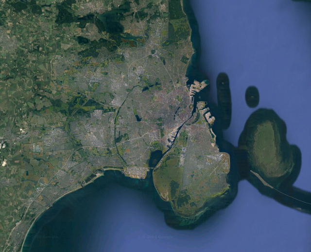
Copenhagen is located on the eastern edge of the island called Zealand in Denmark and spans to the adjacent smaller Amager Island. Zealand is the largest island in Denmark, and lies between the peninsula of Jutland, the largest body of land in Denmark, and Sweden. Between it and Sweden runs the Øresund, the most favorable channel for navigation between the North Sea and the Baltic.
In general Denmark is a very flat country, with few hills and shallow coastal waters. This has meant that it is relatively easy to build artificial land in the midst of coastal waters, creating a very malleable coastline that has been extensively shaped by human artifice over time. This is especially true in Copenhagen, large sections of which are on land “reclaimed” from the sea.

pretty flat


Early Development 1200-1600

In the 11th century Copenhagen (København), initially known simply as Havn (“harbor”), appeared as a fishing village. Its favorable location on the Øresund led to its growth as a town and an increasingly important port. It was given by the King of Denmark to the bishops of Roskilde to rule in 1169. The bishops constructed a castle in the 12th century on a small island in the harbor which came to be known as Slotsholmen (“castle island”). Stone walls were built enclosing the town in the 13th century. As the town rose in importance in international trade, it entered into conflict with the Hansa league, which functioned as a German shipping cartel and sought to control trade routes in the Baltic. The city’s defenses were overrun and the castle destroyed in 1369 by the Hanse, and further wars with the league took place in the early 15th century.
               The city walls concentrated urban life in a limited area. Three gates: west, north, and east, were the only entry points to the city and were locked in the evening. The footprint of these walls, routes leading to and from the gates, and the internal street grid of the medieval town are still evident in the built form of the city. A new castle was built on the ruins of Slotsholmen in the late 14th century, which was occupied by the king in 1416 when the city was reclaimed from the bishops by the royal crown. The site of the castle became the seat of power of the Danish state and continues to be until the present day. By the year 1500 the city’s population was only about 5,000.


Renaissance City 1600 – 1807
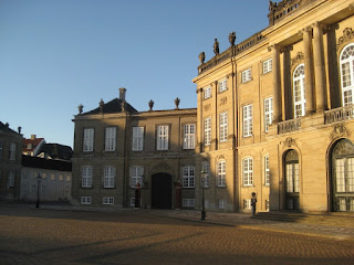
Amalienborg Palace and guard
Throughout the 16th century the city grew in prominence as a port and national capitol. In 1648, after centuries of being elected by leading nobles, the Danish crown became a hereditary absolute monarchy. The consolidation of state power in the city lead had important effects on its development, particularly in the increasingly elevated profile of the monumental architecture of the state and in the social and economic effect of the professional class of bureaucrats, soldiers, and sailors that came to reside in the city. In the late 16th century the city fortifications were expanded and shallow harbor areas were filled in, approximately doubling the city’s size. Later, areas of the harbor would be filled in further increasing the land area of the fortified city. These new areas of the city, the largest of which was to the north of the old town, were platted with a rational grid of streets in contrast to the winding pattern characteristic of the medieval center.

City walls, streets, and developed areas as of 1535 in orange, as of 1750 in pink. 


Nyboder
This renaissance quarters of the town reflects the expansion in state power that took place during this period. The Nyboder (“new houses) complex of rowhouses were constructed beginning in 1631 to house the personnel of the increasingly important Royal Danish Navy. Nyhavn (“new harbor) was developed in the 1670’s as a harbor, mercantile exchange, and maritime gateway to the city via Kongens Nytorv (“King’s new square”), a major civic plaza. North of Nyhavn, the Frederisktaaden area was developed in the early 18th century, featuring the city’s hospital, bourgeoisie mansions and the sumptuous Amalienborg palace complex for the royal family.
Nyhavn
Meanwhile, the island of Slotholmen was expanded considerably and developed with new state buildings, notably the Børsen stock exchange which was constructed in 1640 along with harbor and military facilities. The old castle was rebuilt as Christiansborg Palace in the 1745.


Børsen, with its awesome dragon spire
The 18th century proved to be rich in catastrophes for the city of Copenhagen. The cumulative effect of this was to wipe most of the city clean of its medieval building stock and to launch a major period of reconstruction over a relatively short period of time. The city was hit by plague in 1711 which reduced the population by a third [need source]. This was followed by the Great Fire of 1728 which consumed most of the old town as well as the old castle on Slotsholmen. A second Great Fire occurred in 1794, which again burned most of the old core as well as some of the more recently developed areas to the south and east. Many important civic buildings which were rebuilt after the first fire were again destroyed in 1794, including Christiansborg Palace and the City Hall.

Finally, in 1807 heavy artillery bombardment by the British Royal Navy and an ensuing fire destroyed several important monuments most of the areas of the old town that had been spared from the fire of 1794. The population of the city rose to about 60,000 by 1750 and 100,000 in 1800.

No comments:

Post a Comment